The foundation for Port Coquitlam’s trail network is the Traboulay PoCo Trail, a 25.3 kilometre route that encircles the community, suitable for exploring at any time of the year.
Explore the Trail
The comprehensive trail map includes distance markers, viewpoints, locations of parking and other amenities, as well as descriptions of the flora and fauna found along different sections of the trail.
D ownload our Traboulay PoCo Trail Guide & Map, or pick up a free copy at City facilities.
Trail Emergency Location Codes

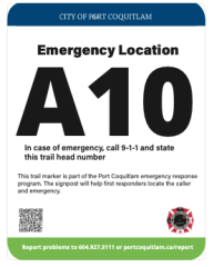
As you enjoy exploring the Traboulay PoCo Trail, watch for trail markers with emergency location codes along the trail in case you need to report an emergency. The City installed the markers at key trail entry points in early 2022 to help 911 callers easily identify their location so that fire, ambulance or fire responders are sent to the right place.
The trail markers with identification codes are shown on the map below.

