
The foundation for Port Coquitlam’s trail network is the Traboulay PoCo Trail, a 25-kilometre route that encircles the community. Suitable for exploring at any time of the year, it traverses a varied landscape that includes forest and creek, meadow and marsh, riverfront and urban development. The loop of gravel and paved paths offers those on foot, bicycle, skate and even horseback an opportunity to enjoy nature, be active and discover the community.
Explore the Trail
Trail Map & Guide
The comprehensive Trail Map & Guide includes distance markers, viewpoints, locations of parking and other amenities, as well as descriptions of the flora and fauna found along different sections of the trail. Download our Traboulay PoCo Trail Guide & Map, or pick up a free copy at City facilities.
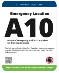
Emergency Location Markers
As you explore the Traboulay PoCo Trail, keep an eye out for trail markers with emergency location codes. These markers were added at key entry points in early 2022 to help 911 callers quickly share their exact location so fire, police, or ambulance crews can respond faster.
The trail markers with identification codes are shown on the map below.
Trail History
The PoCo Trail was born in 1967 as an idea for a Centennial project for the City of Port Coquitlam, to celebrate Canada’s 100th birthday. It began to take shape in the early 1970s, thanks to a dedicated group of volunteers called the PoCo Trail Blazers.
In 1997, City Council adopted a plan to upgrade the PoCo Trail and make it truly a source of community pride. A number of improvements and trail connections were made in the years that followed, resulting in a 25-kilometre loop trail that is now a key year-round attraction in the community.
In 2001, the trail was renamed the Traboulay PoCo Trail in honour of Port Coquitlam’s 13th mayor, the late Len Traboulay, who served as mayor for 19 years.